Cumberland
PASSAGE TO THE CUMBERLAND REGION
DRAFT
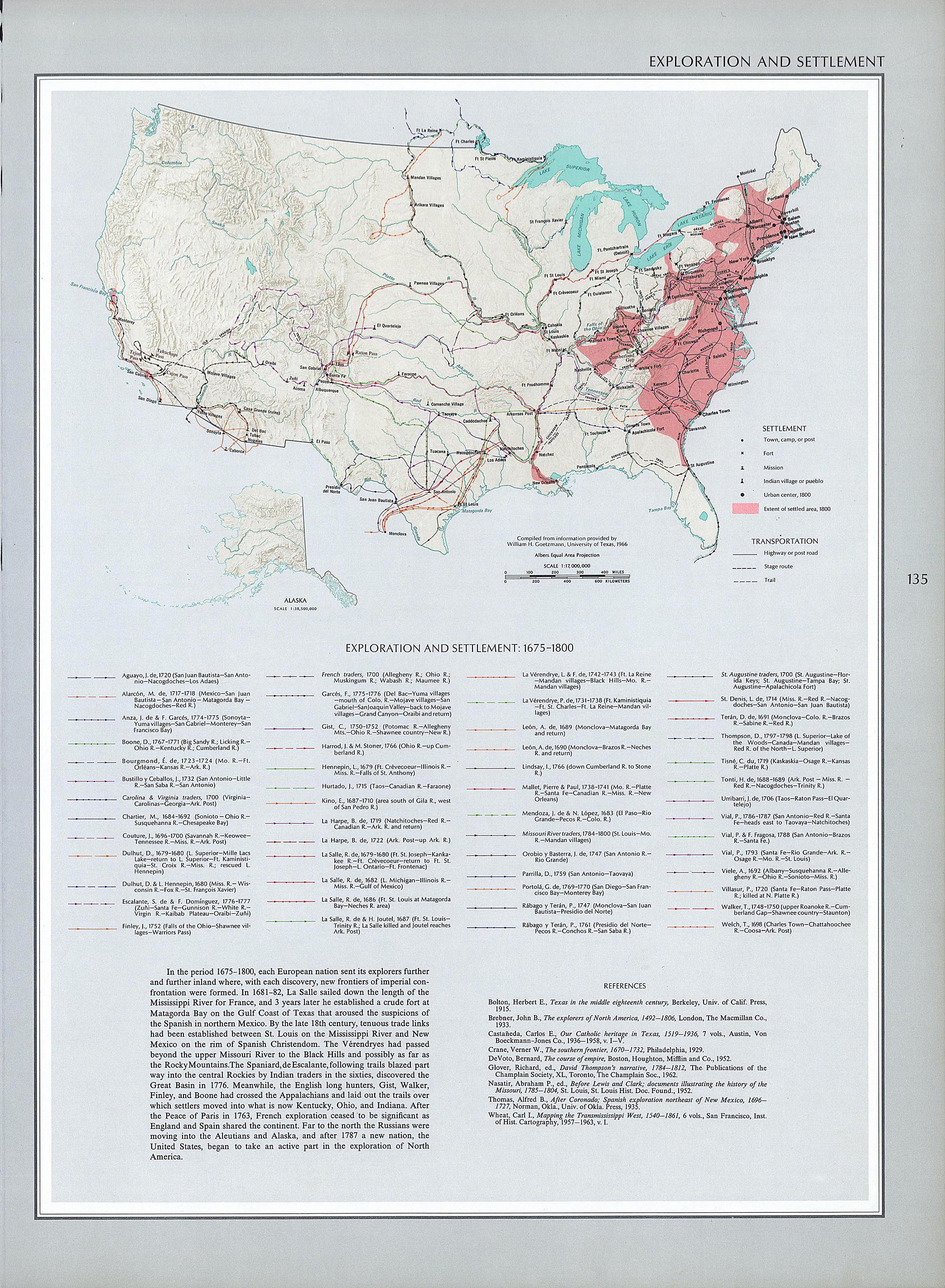
TABLE OF CONTENTS 1) A Journey in History 2) Passage to Cumberland Region (This Page) 3) The Illusive Avery Trace 4) Northeast Cumberland 5) Bell Homestead The following map shows the settlement patterns and routes around 1800.  Settlement in upper Middle Tennessee commenced with Translvania Purchase of Cherokee Indian lands. Passage was facilitated through exploration by Daniel Boone around 1775 into Virginia lands to become Kentucky and James Robertson in 1780 into the Cumberland Region of North Carolina lands to become Tennessee. North Carolina advanced settlement by Military Grants into its Mero District , which comprised a major portion of the Cumberland Region. An act of the North Carolina Legislature in 1786 and a subsequent Act in 1787 authorized the construction of a road to facilitate migration to the Mero District. Most historians identify Peter Avery as blazing a trail to become known as the Avery Trace from Knoxville to Nashville as a result of these Acts. However, the above map is one of the few that actually identify a route between Knoxville and Nashville as the Avery Trace and has resulted in quite a controversy. There is a great deal of confusion linking Peter Avery with North Carolina legislation in 1786 and later to build a road to the Cumberland River region. We have not seen a North Carolina reference to Peter Avery nor are we aware of any. Bill Puryear, Jack Masters & Doug Drake [See http://www.cumberlandpioneers.com/averytrace.html] These historians like us had what we thought would be a simple goal – create a modern map showing the route of the Avery Trace. We never expected the kind of erroneous references and misinformation. According to Ms. Jane Buchanan, who has done more research dealing with Peter Avery than anyone else we know, Peter Avery was never mentioned by North Carolina as having anything to do with any road. It's her idea, and one which we agree with, that the legend of Avery's Trace likely came from stories of Captain McElwee who was an early historian of Roane County, Tennessee. Bill Puryear, Jack Masters & Doug Drake [See ibid] Puryear etal were refering to a 1903 article by Captain McElwee in the American Historical Magazine entitled "The Old Road." Snyder and Pauline Roberts [http://www.roanetn.com/peter.htm] provided few excerpts from the article: A company of men was organized in Washington District as provided for in the Act, and with Peter Avery, a hunter well-skilled in woodcraft as a guide, a blazed trace was marked through the wilderness between the two designated points (Clinch Mountain and Bean's Lick)." One of the whereas items specified, "the levelest and most direct way having regard to the most convenient passage of mountains, fords and rivers." The road from South West Point to post Oak to Kimbrough's Gap to Crab Orchard laid out later (about 1800) "was called the Walton Road which distinguished it from the old NC Road sometimes called the Avery trace. The Walton Road intersected the old NC Road Snyder then suggested that McElwee didn't have his facts accurately stated with [we have summarized] The early Peter Avery family line has been researched by John H. Avery of Colorado Springs, CO since 1914. . . Peter Avery was born May 26, 1739 . . . He died in Roane County in 1816. He enlisted in Capt. Isaac Terbush's company in Dutchess County, NY on June 21, 1761. . . McElwee lists Peter Avery as a non-pensioner Rev. War soldier. No record of his Rev. War service has been found, The State of Tennessee has confounded the confusion in its attempt to identify this route. The Tennessee State Road markers that identify the route of the Avery Trace are absolutely positively incorrect. They show the Avery Trace going through Gainesboro. It did not!!!!! I don’t know what the State of Tennessee officials who set up this historic route were smoking when they created this bogus historical route. Steven Denney [See http://archiver.rootsweb.ancestry.com/th/read/TNSMITH/2002-12/1039233697] Denney is referring to the section of the road that passes through Smith County, but the job did not get any easier or less confusing as we tried to map other sections, especially around Knoxville. Both the references from Puryear etal and from Denney are insightful and should be read in their entirety. We have searched for Tennessee maps that show the location of the roads circa 1800, especially anything labeled "Avery Trace." We found nothing but historically inaccurate trash, including the map that Denney must be lambasting in his comment above. That's when we decided to draw this map from a consensus of the scholarship of this period. We started with the following sketch as an zero’th order approximation of where the historical record says the route was that early travelers used from North Carolina to the Cumberland Region. 
Frontier to Plantation in Tennessee by Thomas P. Abernethy
The 1788 route from Knoxville, crossing the Clinch River, over to Standing Stone (now known as Monterey), crossing the Cumberland River near Fort Blount, continuing onto Dixon Springs, Hartsville, Gallatin, and Nashville comes the closest being Avery’s Trace. It is frequently called Emery Road. The lower 1795 route from Knoxville, crossing the rivers at Fort South West, rejoining the north section near Standing Stone then separating to cross the Cumberland River near Carthage is best known as Walton Road. In 1801 this road became the Cumberland Turnpike and primary passage to the Cumberland Region. With its 15-foot wide clearing, markers every three miles, and frequent wayside inns, it was most likely the way the Bell family took in 1803. They most likely traveled to Fort Southwest Point via Knoxville, Greenville and crossing the Appalachian Mountains from North Carolina. It was not until 1795 that the Walton Road was cut and cleared to a wagon road which later became the Cumberland Road and even later the bed for the Tennessee Central Railroad track. The road was cut from the junction of the Clinch River and the Tennessee River across from Fort Southwest Point to join the Emery Road near Standing Stone and proceed on to Nashville. This road soon became the primary route, replacing the Emery Road section from Clinch Mountain to Standing Stone, used by settlers going to the Cumberland settlements near Nashville. Travel on any unescorted route such as the old Emery Road section was likely to result in death from Indians. [See Smith, DR. Earliest Settlement Routes to Tennessee 9/2/2000. http://smithdray.tripod.com/trailsearly-index-11-1.html] However, the confusion regarding Avery’s Trace and its prominence in upper Middle Tennessee History requires that we give it special attention in the next chapter – The Illusive Avery Trace. By 1803 the roads in North Carolina were better developed than in Tennessee, making it impos-sible to identify the route family Bell might have taken. Roads in 1794 are shown as trace lines on the following map from Halifax to western boarder of North Carolina.  Nevertheless, picking a particular route across the state is likely to have minimal effect on the Bell family experience. Click on the above link to go to the source where you can expand an zero in on the roads. Returning to the Nashville terminus of the family journey, the absence of trails to the western side of the Mero District or Robertson County means that the Bell family loaded themselves and their belongings onto flatboats and floated down the Cumberland River to the Red River and disembarked to their homestead on the north shore of the Red River near Port Royal and major trading station at the confluence of the Red River and Sulfur Fork Creek. Incorporated in 1797 and a thriving commerce center for the upper Middle Tennessee and South Central Kentucky, Port Royal was one of the earliest and most populous settlements outside of Nash-ville. The town no longer exists. It was also the location of the Red River Baptist Church, which figured prominently for the Bell family. Founded in 1791, it was the only church for nearly 200 miles during this period and is still active today in Adams, Tennessee. According to M. V. Ingram's Authenticated History of the Bell Witch, Chapter 1 - Early Settlers ... Along with this tide of immigration came John Bell and his amiable wife Lucy and family of promising children, also a number of likely Negroes, then slaves. They landed with their train of wagons and splendid teams in the west end of Robertson county, Tennessee, near where Adams Station is now located. . . NOTES: The links in this web page were created in 2008. Many of the URLs may no longer be valid. We are trying to replace them, but some are gone forever. |